The Govenor's Palace in Colonial Williamsburg

The Govenor's Palace in Colonial Williamsburg
In the United States, there are several parks set up to recreate the atmosphere of the past.
Showing posts with label I-496. Show all posts

Tuesday, April 6, 2010

I-496 Project

For my Public History class we are working on creating a museum exhibit for the temporary exhibit space at the Michigan Historical Center dealing with I-496.

The class was divided into two teams, one that mainly focuses on the research needed for the exhibit and finding all of the artifacts necessary for it, and the writing team that is actually working on creating the exhibit story line, design, and proposal for the exhibits actual implementation. I am on the writing team, and we currently have a working story line of the exhibit:
  • Introduction: Interstate Highway System
  • Process: Decision Making
    • How, why, and where
    • Real estate segregation and its impact
  • Impact Zone
    • Path of least resistance
    • Controversy
    • What was there
  • Transition of Before and After
  • Construction of the Highway
  • Consequences
    • Paying the Price: Construction and Relocation
      • What was lost
    • Progress section (Shows pro and Con)
      • Integration
      • Economic impact
      • GM
  • Conclusion: Memories
We are constantly going back and forth with the research team in order for us to incorporate what they have found into the exhibit and to tell them what additional information or artifacts we need. We are currently in the process of determining what types of artifacts we want for each portion of the exhibit and creating a floor plan of the exhibit based on the empty template that we have of the temporary gallery floor. We are hoping to make the exhibit in a clover-leaf pattern to imitate the clover-leaf pattern of I-496, as well as have road signs to help guide visitors through the exhibit.

One of our current struggles is finding three dimensional artifacts. Currently, many of our ideas for artifacts are maps, photographs, newspaper clippings, drawings, and graphs. What we really need to do is figure out how to incorporate a large number of physical and interactive artifacts, as least two or three in each part of the exhibit, without putting in things that detract from the main messages of the exhibit. The vast majority of the Michigan Historical Museum's visitors are 3rd and 4th graders, so there have to be lots of different things to catch their interest.

Another current challenge is a website called Omeka, where we are supposed to put digital copies of all of our documents. None of us is very familiar with how to create a digital exhibit through Omeka, and we have been rather disappointed with its capabilities for having a creative and interactive presentation of the exhibit online. We are still working on this.

So, needless to say that we have a long way to go before finishing our portion of this project and since class ends the end of April, not much time to do it in. Hopefully the next few weeks go smoothly and we have something wonderful to present at the end.

Tuesday, March 2, 2010

The Story of I-496

The creation of I-496 in 1965 was part of larger movement involving the creation of the interstate system that correlated with the movement of many people from the cities to the suburbs in the middle part of the 20th century.

Like all technological advances the highway system brought significant change to the country as a whole, the American city and suburb culture, as well as to the individual communities that were completely eradicated by the creation of highways through what was previously neighborhoods.

For our public history course, we will be researching I-496 and its correlation with the larger interstate highway system. We started our research by reading Matt Miller's article, "Looking Back: I-496 Construction: A Complicated Legacy," which mainly focuses on the residents of one of the neighborhoods that was eliminated during the construction process. Under the power of eminent domain the many residents were forced to sell their homes and relocate.

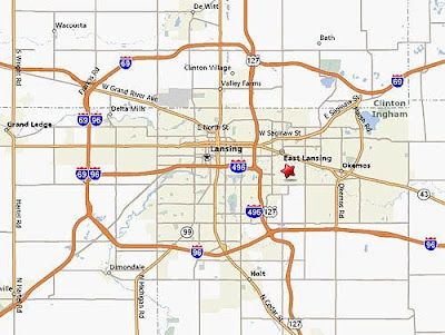
Originally, there were a good number of neighborhoods along I-496, including a neighborhood that had once housed the upper crust of Lansing (but had by the 1960s fallen into disrepair) and the largest Black neighborhood in Lansing, with its own downtown area that was completely eliminated by the freeway. These drastic changes can be seen at the Interactive Material created to accompany Matt Miller's article in the Lansing State Journal. There are also pictures of the construction project underway. Below is an guide to what one stretch of I-496 looks like today:
View Larger Map

So as we embark on this project, we ask a number of questions:
  •  What were the neighborhoods that were eliminated by I-496 like before they disappeared?
  • What types of shops were found in the Black downtown?
  • How many historic houses were destroyed in the old affluent areas?

  • Why was this specific location chosen?
  • Who were the people doing the planning and what were the factors that they considered?
  • Did racism play a role in the decision?
  • How did people feel about this decision?
  • Did the project face much resistance?
  • Were people able to successfully relocate?

  • How is the I-496 project representative of what was going with the interstate highway system on a national level?
  • What does the construction of I-496 say about the public's view of preservation?
  • What can be said about racial housing practices and segregation at this time?