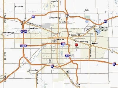
The creation of I-496 in 1965 was part of larger movement involving the creation of the interstate system that correlated with the movement of many people from the cities to the suburbs in the middle part of the 20th century.
Like all technological advances the highway system brought significant change to the country as a whole, the American city and suburb culture, as well as to the individual communities that were completely eradicated by the creation of highways through what was previously neighborhoods.
 For our public history course, we will be researching I-496 and its correlation with the larger interstate highway system. We started our research by reading Matt Miller's article, "Looking Back: I-496 Construction: A Complicated Legacy," which mainly focuses on the residents of one of the neighborhoods that was eliminated during the construction process. Under the power of eminent domain the many residents were forced to sell their homes and relocate.
 Originally, there were a good number of neighborhoods along I-496, including a neighborhood that had once housed the upper crust of Lansing (but had by the 1960s fallen into disrepair) and the largest Black neighborhood in Lansing, with its own downtown area that was completely eliminated by the freeway. These drastic changes can be seen at the Interactive Material created to accompany Matt Miller's article in the Lansing State Journal. There are also pictures of the construction project underway. Below is an guide to what one stretch of I-496 looks like today:
View Larger MapSo as we embark on this project, we ask a number of questions:
 What were the neighborhoods that were eliminated by I-496 like before they disappeared?
- What types of shops were found in the Black downtown?
- How many historic houses were destroyed in the old affluent areas?
- Why was this specific location chosen?
- Who were the people doing the planning and what were the factors that they considered?
- Did racism play a role in the decision?
 How did people feel about this decision?
- Did the project face much resistance?
- Were people able to successfully relocate?


